
Alto Twin (HxGN Smart Sites)
A Digital Twin platform for creating a digital representation of assets, facilities and infrastructure. The system enables monitoring, analysis and simulation of assets and processes in a 3D environment.
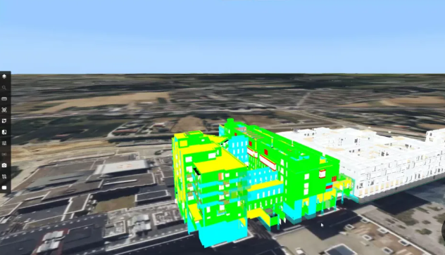
3D Digital Twin
- Display facilities and infrastructure in an interactive 3D environment.
- Combine models, reality meshes and point clouds.
- Navigate quickly between the whole site and individual assets.
- Present operational and engineering data in spatial context.
Change analysis over time
- Compare states, infrastructure and assets over time in a single environment.
- Analyze changes between historical states and the current state.
- Filter information by time periods, events or attributes.
- Identify trends, anomalies and impacts on infrastructure and assets.
Unifying data from multiple systems
- Combine data from BIM, CAD and GIS systems.
- Connect to existing enterprise systems without replacing them.
- Integrate IoT data, sensors and real-time sources.
- Create a unified situational picture of all assets and infrastructure.
Real-time monitoring
- Connect to cameras, sensors and control systems.
- Receive alerts and events in real time.
- Monitor personnel, equipment and environmental conditions.
- Improve response times and incident management.
Data analysis & investigation
- Take measurements and cross-sections in 3D models.
- Compare scenarios and data versions.
- Analyze changes over time.
- Support planning, maintenance and decision-making.
Data security & permission management
- Connect to enterprise authentication systems.
- Manage permissions by roles and users.
- Protect sensitive data.
- Securely share data between different units.
Frequently Asked Questions
What is a Digital Twin and how does it help an organization?
A Digital Twin is a digital representation of assets, facilities and infrastructure that combines engineering, geographic and operational data in a single environment. The system lets you see the state of infrastructure in real time, detect anomalies, plan actions and improve decision-making throughout the asset's lifecycle.
How is Alto Twin different from a standard GIS?
While a GIS focuses on displaying and analyzing geographic data, Alto Twin provides an operational Digital Twin that combines engineering, geographic and real-time data in a single environment. It lets the organization see the state of assets and infrastructure in real time, analyze events and turn information into fast, data-driven action.
How does Alto Twin help with decision-making?
The system provides a unified operational picture that combines historical, current and real-time data. It also includes tools for measurement, cross-sections, data comparison and analysis that help understand trends, identify problems and make data-driven decisions.
How does the system support non-GIS users?
The system includes a dimension-based interface that lets users find information by location, time or business attributes, without requiring professional GIS knowledge.
Interested in this product?
Fill out the form below and our team will get back to you shortly.